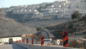
Israel paving road to link East Jerusalem neighbourhoods to city center
 Friday, December 2, 2011 at 12:28PM
 New route would link northeast neighborhoods to capital's main Begin Boulevard; Peace Now: Plan is illegal use of occupied land, endangers two-state solution.
By Akiva Eldar Haaretz 2 December 2011
The city of Jerusalem began works two weeks ago on a road that will connect the capital's northeastern neighborhoods to Jerusalem's main traffic artery, Menachem Begin Boulevard, as part of a policy to stregthen bonds between neighborhoods across the Green Line and the rest of the city.
The neighborhoods to be connected by the new route are Pisgat Ze'ev, Neve Yaakov, Anatot, Shoafat, and Beit Hanina; the route 20 project will also link Jerusalem's northern neighborhoods with route 443, which in some places crosses through the West Bank.
 Works on road to link E.Jerusalem neighbourhoods to city centre, Nov 30, 2011 Photo by:Michal Fattal
Jerusalem's municipality, along with the Moriah Jerusalem Development Company, is advancing the project with an investment of over NIS 150 million. Work is expected to go on for 14 months.
The next stages will see the completion of a bridge over route 50, with another bridge to be constructed over Nahal Atarot due east. Route 20 will be extended to link the latter to Beit Hanina intersection.
Moriah director general Alex Weisman was cited by the Mateh Beinymin Regional Council's website as saying that in recent years "route 20 has become an important tool to develop those parts of the city which it serves."
Weisman added that he was "sure that linking the connection of the city's northeastern neighborhoods would enable the development of the area and will benefit the entire city."
The plan was approved a year ago by the planning committee of the West Bank's civil administration, after the panel had rejected the opposition by the NGO Peace Now.
Peace Now representatives argue that the "road's current route isn't legal, since the plan designates occupied territory for permanent infrastructures for the occupying power, while completely disregarding the needs of the Palestinian residents in Beit Hanina and the area."
The planning committee also rejected opposition submitted by Beit Hanina residents, who claimed the project would confiscate two dunams of the neighborhood's land, after already "confiscating 5,000 dunams for the construction of the Pisgat Ze'ev settlement."
Following orders by the Attorney General, an engineering solution was found which would limit the "slide" into West Bank territory to a few dozen meters.
Hafit Ofran, head of Peace Now's settlement tracking team, told Haaretz that the construction of such an infrastructure was in conflict with Israel's interest in reaching an agreement with the Palestinians and endangers the two-state solution.
Pisgat Ze'ev's website wrote in response to the objections that, "while the paving of route 20 would make life easier for Pisgat Ze'ev residents, it would also make it easier for the residents of Arab neighborhoods in the area, such as Beit Hanina and Shoafat.
At first, route 20's construction was approved in August of 2005, when Israeli public attention was diverted to the disengagement from the Gaza Strip. The government decided then to order the Transportation Ministry to conduct the route 20 works at a cost of NIS 80 million, through the ministry's municipal roads budget.
Another clause in that decision sought to back Jewish settlements in Arab East Jerusalem neighborhoods by allocating NIS 50 million to restore, develop, and maintain the Old City and Mount of Olives.
It was decided that the "budgets would be handled as a separate financial sector, with the aid of subcontractors."
 APJP |
  Post a Comment |