The Hidden Agenda: The Establishment and Expansion Plans of Ma'ale Adummim and their Human Rights Ramifications
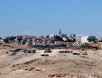
Ma'ale Adummim is the largest Israeli settlement in its jurisdictional area (some 4,800 hectares) and the third largest in population size, after the ultra-Orthodox settlements of Beitar Illit and Modi'in Illit. Its city limits, which include the city's neighborhoods and the Mishor Adummim Industrial Zone, encompass a vast swath of land deep in the West Bank. Many Israelis consider Ma'ale Adummim an Israeli city that will remain under Israeli control in any final-status agreement reached with the Palestinians.
You Tube:Dispossession of Bedouins in the Ma'ale Adummim area 2
http://www.youtube.com/watch?v=uhlrG2z2ccw
Under the Guise of Legality: Declarations on state land in the West Bank
In accordance with this conception, Israeli governments have taken measures in recent years to strengthen the spatial and functional ties between Ma'ale Adummim and Jerusalem. The planning authorities have approved an outline plan for residential neighborhoods in E1, an area that lies within Ma'ale Adummim's city limits and borders Jerusalem's jurisdictional boundary. Due to objections made by the US Administration, the neighborhoods have not yet been built. However, despite the American opposition to construction in E1, Israel moved the Samaria and Judea Police District headquarters there. While constructing the police headquarters, Israel paved roads and built infrastructure to serve hundreds of housing units planned to be erected nearby.
The route approved by the government for the Separation Barrier in the area will leave more than 6,000 hectares on its “Israeli” side, including not only Ma'ale Adummim's built-up area (400 hectares), but also extensive swaths of land for future expansion of the settlement. Although construction of the Barrier has stopped - officially due to budgetary constraints - the plans to complete it along the designated route, thus annexing extensive areas of land to Israel, remain in place.
This report - a joint effort of Bimkom and B'Tselem - examines the spatial and planning aspects of these recent actions, frames them within a historical perspective and reveals documents from the Israel State Archives only recently made available to the public. These documents show that although the area of Ma'ale Adummim is occupied territory, the government of Israel has viewed it from the outset as a means to serve the internal needs of Jerusalem. Under international law, Israel holds this occupied territory in trust and is forbidden to use it for its own purposes.
Already in late 1974, the government decided to build Jerusalem's new industrial zone in Mishor Adummim, as well as a workers camp nearby. A few months later, in 1975, Israel expropriated 3,000 hectares to build Ma'ale Adummim. More land was subsequently expropriated to enable the settlement's expansion, to pave roads, and to develop other public infrastructure in the city. The expropriation procedure used in Ma'ale Adummim is unprecedented in the settlement enterprise. Expropriation of land for settlement purposes is forbidden, not only under international law but also according to the long-standing, official position of Israeli governments. Most settlements were built on area that was declared state land or on land that was requisitioned - ostensibly temporarily - for military purposes. It appears that in Ma'ale Adummim, the government decided to permanently expropriate the land because it viewed the area as an integral part of Jerusalem that would forever remain under Israeli control.
The thousands of expropriated hectares were not uninhabited land. To allow the construction of Ma'ale Adummim and its expansion, hundreds of Jahalin Bedouins were expelled from their residential sites, which were designated for the neighborhoods of the settlement. Residents of adjacent Palestinian communities - al-‘Eizariyah, Abu Dis, and ‘Anata - were also severely harmed by the construction of the settlement, which took over many of their land reserves. For example, some 650 of the 1,135 hectares of al-‘Eizariyah land now lie within the city limits of Ma'ale Adummim, leaving the Palestinian town with a severe shortage of land reserves for development and with highly crowded residential areas.
The geographic location of Ma'ale Adummim also infringes the collective right of the Palestinian people to self-determination. The settlement severs the West Bank at a strategic point, dividing it into two cantons, thus making it impossible to establish a viable Palestinian state with reasonable territorial contiguity.
Completion of the Separation Barrier along its approved route and implementation of the building plans for E1 in their entirety will worsen the infringement of Palestinians' human rights.
 APJP
APJP