The E1 Settlement is not Ma’aleh Adummim: Ir Amim -position paper
April 2005
Ir Amim Position Paper
The E1 Settlement is not Ma’aleh Adummim
Political Ramifications of the E1 Area
The area of land that has become popularly known as E1, to the north and west of the Jerusalem-Ma’aleh Adummim road, is constantly in the headlines lately. The Israeli government is currently making a number of decisions, including erecting the Separation Fence around this demarcated area, which will enable the building and settlement of E1.
Government spokespeople emphasize the need to connect the E1 area to Jerusalem, while others – among them even some Coalition members – not only sound less convinced regarding this matter, but their words are in fact at cross-purposes to the declarations of an unconditional obligation to settle this particular area.
It is obvious that the inconsistencies heard in Israel’s declarations are due to pressures brought to bear by the American Government for Israel to adhere to its commitment to the “Road Map,” and to abstain from any new building outside the existing built-up areas.
Allegedly, this controversy pertains to the city of Ma’aleh Adummim to the east of Jerusalem.
But E1 is not a part of Ma’aleh Adummim, as this city is built today, and should be seen for what it really is – a separate settlement – which, if built, will have long-term repercussions on the political process between Israel and the future Palestinian state. In fact, the development of E1 will split the West Bank in two and will create Israeli hegemony over Arab Jerusalem. This course of action may not only compromise the possibility of reaching an agreement, but can even prevent the opening of negotiations between the sides.
The present route of the Separation Fence around E1 discloses ulterior political considerations rather that security ones, which do not serve the Israeli national interest. The intended route will create a dismembered West Bank, lacking the geographical integrity necessary for viable living conditions.
The need for physical contiguity between the different portions of the future Palestinian state will not be served through the construction of a number of bridges and tunnels. These will indeed connect the northern and southern parts of the West Bank, but this solution is barely sufficient, and will prevent the existence of a lively, self-propagating economy or the complete autonomous functioning of this area.
Moreover, Israeli control of the E1 region will thwart any options for the development of East Jerusalem, and will drive a wedge between East Jerusalem and its surroundings, that will prevent its functioning as a central city within the future Palestinian state.
The entire region of which Jerusalem is the center will – especially after the completion of the E1 plan – be under Israeli control, and will be characterized and defined by the “Jerusalem Security Envelope”. As a result, Palestinian villages such as Anata, Abu Dis, Azaria and A-Zayim, will not be integrally connected to the northern and southern parts of the West Bank (and not even to Jerusalem itself), and will lose their natural connection to East Jerusalem, without establishing alternative connections with the Palestinian region itself.
Background Information
Ma’aleh Adummim: Building of the city commenced in 1975, and today the population has reached approx. 27,000. According to municipal plans, the expected population growth is 50% within the next five years, and a large portion of this growth is expected to be in the E1 area. (See below.)
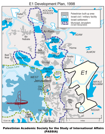
E1 (derived from “East 1”) is a term applied by the Ministry of Housing to what is currently part of the municipal plans of Ma’aleh Adummim – in the area to the north of the Jerusalem-Ma’aleh Adummim road. E1 touches the edge of the municipal boundary of Jerusalem, as well as the neighborhoods/towns of Anata, Abu Dis, Azariya and A-Zayim that lie on the eastern border of the city.
When the Ministry of Housing commenced the planning of E1, the intention was to establish a new settlement city between Ma’aleh Adummim and Jerusalem. It was only later that E1 was included in the municipal plans of the greater Ma’aleh Adummim.
Area: The entire municipal plan for Ma’aleh Adummim covers an area of 53,000 dunam (53 sq. kilometers) -- larger than Tel Aviv or Beersheba. However, the actual built-up area of Ma’aleh Adummim covers only 15% of the planned area --approx. 7,000 dunam (or 7 sq. kilometers).
E1 is planned to spread over 12,000 dunam (12 sq. kilometers). The area is located on the hills between Ma’aleh Adummim and Jerusalem, controls the main arteries of the region, and touches the municipal boundary of Jerusalem.
Traffic Arteries: E1 is situated to the north and west of the Jerusalem-Ma’aleh Adummim-Jericho road, and from the north is bordered by Road 437 (Adummim-Ramallah) that today is the main central traffic route for Palestinians traveling from Bethlehem to Ramallah.
Land Ownership: Most of the lands included in the municipal plans of Ma’aleh Adummim are today National Lands (following a problematic process which enabled this). There are still a few Palestinian-owned enclaves within the area, but these are not included in the development plans.
Population Density: On average, approx. 2,000 sq. meters per person in Ma’aleh Adummim, as opposed to approx. 100 sq. meters per person in the neighboring Palestinian towns.
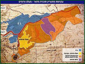
The Development Plans for E1 include:
- · The erection of at least 3,500 housing units (for approximately 15,000 residents) – as per government sources. This plan, including widespread construction (both multi-story apartment buildings and villas), was recently approved by the Ma’aleh Adummim municipality, although approval has not yet been given to submit the plan for public review
- ·The transfer of the "Shay" (Judea and Samaria) Police Headquarters from its present location in Ras el Amud to E1 - this has also been approved by the Maaleh Adummim municiplaity, but likewise, has not been submitted for public review
- · An economic development Zone- a joint venture of the M.A and Jerusalem municipalities - this is the pnly part of the E1 plan that has already received all final authorizations required for building to commence. THe approved area for building encompasses approx. 1 million sq.metres (on an area sufficient for 10,000 housing units). It is situated in the N.E of E1, whicjh borders on the village of Anata and is adjacent to the new Border Polce HQ on the Maaleh Adummim-Jerusalem road.
The plan also includes the following components:
- · Commercial areas
- · Hotels and “special housing”
- · Universities and “special projects”
- · Cemetery
- · Waste disposal site
- · A massive park - about 75% of the plan's tota; area is earmarked for a park that will surround all teh above components.
The E1 development program contains no reference at all to the Palestinian population in the area, as regards hospitals, schools, cemetery etc. As indicated above, most of the area has been declared National Land. It needs to be emphasized that not one of the few Palestinian enclaves located within E1 and not yet confiscated have been included in the development plans (a fact that is against all professional standards in and for itself).
Ma’aleh Adummim is not E1
E1 is not an inseparable part of today’s city of Ma’aleh Adummim. It stands to reason that the inclusion of E1 in the municipal plans of Ma’aleh Adummim is intended to cloud the true significance of this construction.
Formally, the construction in this area is explained as a security requirement to defend Jerusalem, as part of the concept of the Separation Fence that Israel has been building for the last two years.
In January 2005, a Government decision determined that north of Abu Dis, the fence will depart from the Jerusalem municipal boundary, will extend eastwards, and will completely surround greater Ma’aleh Adummim – far beyond the already massive area included in the city’s master plan. The route of the fence will exceed the municipal boundary of Jerusalem considerably, with the obvious purpose of physically connecting Jerusalem with Ma’aleh Adummim, and enabling implementation of the E1 plans.
An important detail that is often misrepresented is the nature of the objections of the American government and other international players against Israel’s policies regarding the area in question. These objections are not directed towards the city of Ma’aleh Adummim as it is built today, but only against the proposed demarcated area of E1. This distinction is paramount, as the Americans, and even the Palestinians, are willing to accept an Israeli presence in Ma’aleh Adummim; but not in E1.
It seems that this insistence to build up E1 is intended to pre-determine the future borders in the Jerusalem region, in a unilateral manner that will impact any future permanent settlement – by creating an irreversible reality (as opposed to a fence, which can be dismantled or moved from place to place). Thus it is not by chance that promotion of the E1 plans are coming to fruition at this particular time – a time when a tiny window of opportunity is opening towards the renewal of negotiations between Israel and the Palestinian Authority.
Alternatives and Differing Approaches to E1 and Ma’aleh Adummim
From the beginning of the official negotiations regarding a permanent settlement, the Israelis and Palestinians reached an understanding that Israel would retain three settlement blocs – Ma’aleh Adummim, Gush Etzion and Ariel.
The E1 area was included within the municipal boundary of Ma’aleh Adummim at the time of the Rabin government in 1994. However, Rabin avoided execution of the plans in the area, and it is believed that there was an understanding between Rabin and the Clinton Administration that the future of this area would be determined in the course of negotiations between the sides.
A few years later, Prime Minister Netanyahu commenced official procedures to authorize in principle allocation of the lands in question under the Ma’aleh Adummim master plan. Netanyahu even initiated an “umbrella municipality” for Jerusalem and Ma’aleh Adummim – a move that met with American objections and resulted in a stalemate for the plans of the area.
Prime Minister Barak also expressed his support in principle for the development of E1, but at the same time agreed to include this topic in the framework of negotiations with the Palestinians. And indeed, during the Taba talks in January 2001, Israel presented a map of Ma’aleh Adummim that included the E1 area. Israel argued the need to retain all of this area for security requirements (also from the direction of the Jordan Valley). But as soon as the map was presented, it became evident to the Palestinians that the area in question was much broader than the currently built-up area of Ma’aleh Adummim. From that moment the Palestinian rescinded their agreement to recognize Israeli’s continued hold of the city, and declared their desire to dismantle the entire bloc.
Double messages of this nature continued to accompany discussions on this topic even during PM Sharon’s first government. In 2002, Binyamin Ben Eliezer, then Minister of Defense, signed the master plan for the area, thereby awarding it official status. But at the same time, Ben Eliezer gave a commitment to the American government that the plan would not be executed.
Despite its lack of official standing, the Geneva Initiative of October 2003 should also be noted here. In this Initiative, the sides reached an agreement that the city of Ma’aleh Adummim would be included as part of Israel. This understanding pertained to the built-up city as it stands today, plus a small addition to meet the needs of future growth. In accordance with this Initiative, the road connecting Ma’aleh Adummim with Jerusalem through the Mount Scopus tunnel would remain under Israel’s sovereignty (as well as 100 meters to each side of the road), and it was to be locally defended, as would the city of Ma’aleh Adummim itself.
Actual construction in the E1 area finally commenced only last year (2004). The work was executed by the Ministry of Housing under Minister Efi Eitam. As at that time, the statutory Urban Plan for the area in question had not yet been approved, the work was formally illegal, and was stopped (due to international pressure) just a short time after it was begun. The work included preparation of the main access roads to the area, as well as preparing the ground for the transfer of the “Shay” Police headquarters from its present location in Ras El Amud.
At the beginning of 2005, the Ma’aleh Adummim municipality approved two detailed urban plans for the development of the area, as mentioned above: one for approximately 3,500 housing units (apartment buildings and villas), and the second for the transfer of the Police headquarters. This initial approval is the first stage towards securing final authorization of the plans, which can only happen after they have been submitted for public review, and objections registered – a process that could take but a few months.
Ir Amim’s Position
The building and development of the E1 area are not intended to serve the security needs of either Jerusalem or Ma’aleh Adummim. The settlement that is proposed to be built in this area differs in principle from the city of Ma’aleh Adummim -- both topographically, as well as in its anticipated ramifications. E1’s inclusion within the boundaries of the city was designed to give the impression that they are one and the same. But this is not the case.
Without prejudicing the status of the city of Ma’aleh Adummim as it is built today, Ir Amim maintains that it is necessary to preserve the uninterrupted territorial contiguity of the future Palestinian region with East Jerusalem, for the sake of the national interests of the State of Israel.
The permanent borders of the area should be determined in negotiations between the sides. Until then, no unilateral actions should be taken that could harm the feasibility of such negotiations.
For these reasons, Ir Amim objects to the building of the Separation Fence around E1, to the proposed construction in the area, and to the creation of a wedge between the West Bank and East Jerusalem.
***********************************************************************
Ir Amim (“City of Nations” or “City of Peoples”) is an Israeli non-profit, non-partisan organization founded in order to actively engage in those issues impacting on Israeli-Palestinian relations in Jerusalem and on the political future of the city. Ir Amim seeks to render Jerusalem a more viable and equitable city, while generating and promoting a more politically sustainable future.
Bearing in mind the symbolic and actual status of Jerusalem as a city of two peoples and three religions, as well as the city's pivotal role in reaching a political agreement, Ir Amim aspires to a stable Jerusalem, equitably shared by the two peoples; a city that ensures the dignity and welfare of all its residents and that safeguards their holy places, as well as their historical and cultural heritages.
Ir Amim offers its knowledge and expertise concerning the political, economic and social conditions in Jerusalem to a range of organizations and individuals, including governmental and municipal authorities who deal with the management of the city, and Track II parties who examine the sustainability of possible political arrangements.
Ir Amim has ongoing working relations with the Palestinian community in Jerusalem, as well as with key players in the international community active in Jerusalem issues.
Ir Amim operates a range of complementary activities:
- Monitoring and exposing critical developments in Jerusalem, and informing / alerting target audiences in Israel and in the world.
- Legal advocacy aimed at halting or mitigating unilateral actions that harm the fabric of life in Jerusalem, and create obstacles to reaching an agreed-upon future for the city and the region.
- Policy advocacy with decision makers, both local and international.
- Public outreach and media work aimed at raising awareness of developments in the city and understanding of their local and global significance. Activities include study tours of East Jerusalem, professional seminars and public events.
- Strengthening, and working with, civil society organizations in East Jerusalem to advance a more equitable Jerusalem.
The information and analysis in this paper are based, in part, on the following sources, to whom we offer our thanks:
- · Architect Shmulik Groag – “BIMKOM, Planners for Planning Rights”
- · “On the Slopes of Annexation” – a B’tselem Report, June 1999
- Menahem Klein: “Doves over Jerusalem” – published by the Jerusalem Institute, 1999
 APJP
APJP