THE POLITICS OF ISRAELI ARCHITECTURE & PLANNING
THE POLITICS OF ISRAELI ARCHITECTURE & PLANNING
By Abe Hayeem RIBA, NRAC – updated 9th June 2006
The current boycott and blockade by Israel of the West Bank and Gaza together with the Israeli Prime Minister, Ehud Olmert’s declaration of unilateral disengagement and ‘convergence’ with Israel ’s borders defined by the illegal Annexation Wall, make a viable Palestinian State virtually impossible. The essential elements of apartheid - exclusivity, inequality, separation, control, dependency, violations of human rights and suffering -- defines the relationship between Israel and the Occupied Territories/ Palestine.
Today, 200 exclusively Jewish settlements housing some 400,000 Israelis are dotted across the Occupied Territories : about 200,000 settlers live in the West Bank , 200,000 in East Jerusalem . Those that were ‘disengaged’ from Gaza last year (2005) will now be settled on both sides of the Green Line.
Creating the physical reality of Israeli and Zionist aims and policies of settlement, requires the expertise of architects, planners, economists and other professionals. The most significant aspect of Israeli architecture is its political dimension. This was explicitly presented in a study done by Rafi Segal and Eyal Weizman as Israel ’s exhibition entry to the International Union of Architects Conference in 2002 in Berlin . When the Israel Association of United Architects (IAUA), saw the catalogue of the exhibition, it reacted with fury and ordered its withdrawal.
Esther Zandberg wrote in Haaretz, “the Israeli community of architects very piously follows a total separation between ‘pure’ professionalism and "dirty" politics. The chairman of the association at the time , Uri Zerubavel, wrote to the curators of the UIA exhibition, that the IAUA ‘represents its members in regard to their profession and not in regard to the political aspect.’ But as the catalogue authors state, “planning decisions do not generally stem from economic or ecological considerations, but are meant to serve strategic national goals. The clearest expression of the conflict is the processes of change, adaptation, construction and erasure of the open landscape and the built-up surroundings. The singular topographic conditions [in the West Bank] dictate the points of friction, and the terrain becomes a field of battle on which themes of power, control, and resistance are played out."
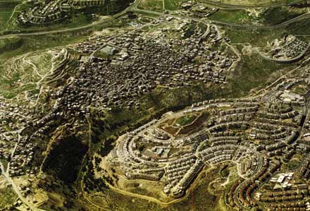
Even before the insidious meandering Apartheid Wall began swallowing up whole towns and agricultural land and aquifers within the West Bank, the policy has been the merging of the towns and settlements on either side of Green Line into contiguous urban blocs - as with settlements Hashmonaim Modi’in Illit -Matityahu with Hevel Modiin within the line. The line of the Wall now encompasses whole Israeli settlements, many kilometres west of the
Green Line. Palestinians stranded east of the new Wall become, in effect, non-citizens in their own homes in the “Seam Zone”. Their homes are sequestered and destroyed if in the way of a new road or the new Wall Route.
‘Metropolis’ master plans were prepared years ago for the Government by the Jerusalem Institute for Israel Studies. Each town has municipal boundaries and regional councils that far exceed their built areas, allowing for future expansion, in essence to “plan out” the Palestinians, who even in areas A and B (total and partial Palestinian control) are restricted to minimal areas and in their expansion. The Metropolis of Jerusalem comprises the old municipal boundaries during Jordanian rule upto 1967, but has since been expanded to annex and expropriate illegally huge tracts of land and Palestinian villages like Abu Dis, Anata, Az-za’im and Al- Azariyah, surrounding and suffocating them, while extending their new boundaries to build new settlements like Gilo, Har Homa, and Giv’at Hamatos.
The land corridor “E1” links up with larger settlement blocks like Ma’ale Edummim extending to Jericho in the East, blocking the expansion and development of Ramallah to the north, and linking with the “community settlements” in the Western Hills thus separating the villages and towns between Bethlehem and Hebron. Ariel, the now well- developed settlement town built in the heart of Samaria halfway between Nablus and Ramallah, has huge tracts of land stretching out quite unnecessarily in all directions. This means that the Israeli planning system was based not on urban planning considerations, but to create as long a barrier as possible separating Palestinian communities by highways, and disrupting the territorial contiguity of this area. Thus the machinery of oppression strangles and imprisons, literally, the Palestinians within their own towns, as travel is practically prohibited into Jerusalem and between major towns in the West Bank unless under the most stringent conditions.
The labyrinthine planning laws make expansion and building or extending houses for Palestinians on their own land an impossibility, and extremely expensive, thus forcing them to build illegally. There is the famous case of Salim Shawamreh who has had his house demolished four times, which ICAHD (Israeli Committee Against House Demolitions) has now rebuilt for a fifth time as a peace centre, again under the threat of army bulldozers. The difference in dealing with Palestinians in the OPT’s and even within Israel is glaring. Land is requisitioned if it has not been cultivated for more than three years, and houses built on it demolished. In the Negev, the latest assault is on Bedouin towns and encampments, and “unrecognised villages” which receive no state benefits, and are now being requisitioned, houses, schools and mosques demolished, to be replaced by housing for Jewish Israelis, such as “Blueprint Negev” sponsored by the Jewish National Fund.
The illegal settlements and towns in the West Bank, built in circular rings of houses and roads on hilltops create a dominating presence overlooking Palestinian villages and towns, with the highways that slice through the valleys and demolishing any houses and agricultural land that may exist in their path, creating the “Politics of Verticality”.
As Gideon Levy points out in his contribution to the catalogue “from everywhere you can spot the settlement on the hilltop, looming, threatening, dreadfully colonial. The breaching of international law that explicitly prohibits the transfer of civilian population into occupied territory - an act considered a war crime by the Fourth Geneva Convention - is overlooked by Israel.”
In an interview with Thomas M. Leitersdorf, the Israeli architect who trained at London’s Architectural Association, describes how he designed Ma’Ale Edummim, directly next to Jericho at the end of the desert, the farthest place to Israel that was conceivably possible, on order from the Ministerial Committee for Settlement then headed by Ariel Sharon. “The strategy in Judea and Samaria at the time was to ‘capture ground”: you capture as much area as possible by placing few people on many hills. The underlining political idea stated that the further inside the Occupied Territories you placed settlers, the more territory Israel would have when the time came to set the permanent international borders- because we were already there.” While admiring the beauty of Arab villages, he said practicalities and ministerial requirements made it difficult to emulate them. The incongrous trademark of red- pitched roofed houses and villas, sold at hugely reduced prices to attract the middle classes, and Russian immigrants pepper the biblical landscape. “As to the politics of Jews and Arabs I cannot contribute because I am very weak on politics. To tell you that an architect influences politics? He doesn’t. The whole story of Judea and Samaria could have been different, but this is on levels that are neither in your hands nor in mine.”
Apart from a few honourable exceptions, Israeli architects never seem to have examined their actions critically. There is little self-examination or moral stocktaking , particularly among its veterans, who have never seen the national conflict as involving themselves. As Weizman says “The use of civilian architects for military purposes is unethical. When an architect works for the military, he knows he is designing for military use. When he thinks he’s designing for civilian use, but it is used to enforce a military agenda, it’s wrong.”
Abe Hayeem
References:
“Land Grab” - B’Tselem Report ,May 2002 < www.btselem.org>
“A Civilian Occupation -The Politics of Israeli Architecture” -Rafi Segal & Eyal Weizman - Verso Press
“The Politics of Verticality” Eyal Weizman <www.opendemocracy.net>
 APJP
APJP