To Start a City from Scratch: New Israeli Towns in the Occupied Territories
To Start a City from Scratch: New Israeli Towns in the Occupied Territories
An interview with the Architect Thomas M. Leitersdorf, Tel-Aviv, 22nd of April 2002.
Thomas Leitersdorf heads a leading architectural and town-planning practice in Tel-Aviv. He was educated at the Architectural Association in London and began his career working with Bill Perera in the United States on town planning projects in Orlando, Florida and in the Ivory-Coast, where he planned the expansion of the capital Abidjan. Leitersdorf returned to Israel in the 1970s, and has since become one of the most influential architects, whose projects within and beyond the green-line have been widely acclaimed.
Leitersdorf designed two cities in the West Bank, Ma’ale Edummim and Emanuel. Ma’ale Edummim, located east of Jerusalem on the mountains of the Judean Desert, was built by the Israeli Government and grew to become the largest Israeli city-settlement in the West Bank. Emanuel, located south-west of Nablus and the first town to be built for the Ultra-Orthodox, was one of the largest settlements that were designed and built by the private sector.
The interview seeks to describe a practitioner's point of view: the professional considerations in building new cities in mountainous regions. The fact that these cities are in effect Settlements built in occupied land, means that ‘professional’ consideration had to deal with the political objectives of the State, as well as with the security and the social realities in the West Bank.
How did you come to work on the planning of Ma’ale Edummim?
When I returned to Israel we began work on the National Masterplan for Tourism with the Minister of Tourism at the time, Gideon Pat . He introduced me to the planning of Ma’ale Edummim.
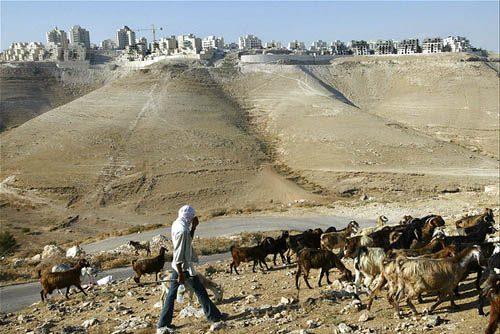
The strategy in Judea and Samaria [i] at the time was to ‘capture ground:’ you capture as much area as possible by placing few people on many hills. The underlining political idea stated that the further inside the Occupied Territories we placed Settlers, the more territory Israel would have when the time came to set the permanent international borders – because we were already there. This was similar to the strategy employed in Yamit. [ii]
It was a government decision to build Ma’ale Edummim directly next to Jericho and its location was accurately specified – at the ‘end of the desert,’ the farthest place from Israel that was conceivably possible.
I was given map-coordinates and was told to build a town. How big? – The biggest possible.
When I went to see the site I noticed a number of things. The morphology of the area was highly irregular and in order to build a town there you would have had to flatten it entirely. The site was suitable for building nice hilltop villages, but it was not a site for a larger town. In addition, it was climatically suffocating: at the point where the mountains start to rise you get all the winds from the existing industrial area and you can hardly breath. The decision on Ma’ale Edummim’s location was, without doubt, political.
I returned to the Minister and told him that to the best of my knowledge this was not a place to build a town. He replied that, with all due respect, this was a government decision and that in one hundred and twenty days the bulldozers have to begin work on the site. I proposed, therefore, to design two alternatives – one where the government wanted, and the other where I saw fit. But to do so, I said, would cost the government money. I required a complete team of consultants that included economists and climate specialists.
After sixty days I returned to the Minister with three alternative sites, including the one suggested by the government. These were rated according to the morphology of the terrain, the climate, accessibility to infrastructure, and proximity to employment centers – the ABC of town planning.
Were these parameters that you yourself defined?
Yes. No parameters were given to me. All I was told was ‘to build a town here.’
In order to persuade the Minister, I quantified and qualified the alternatives in terms of cost per housing unit, natural conditions, and accessibility. He was convinced the moment he saw the proposal. In fact, it was his idea not to build just another Settlement with mobile homes. The idea was to take land that is State Land proper and build a city that can compete with any other city in terms of its services and the type of housing that it offers. This was revolutionary, compared to what went on before – as many hills as possible, as far as possible.
When we put the alternatives to the Ministers Committee for Settlement, headed at the time by Ariel Sharon, the only questions asked were:
‘Which of the alternative locations has better control over the main routes? And which town has a better chance to grow quickly and offer qualities that would make it competitive with Jerusalem?’
I replied that according to these criteria the ideal location would be location A – that which sits between the desert and the inhabited land, still benefits from rain and vegetation, has proximity to existing infrastructure and to an important international route of historical significance, which begins in Jerusalem and passes by Jericho on the way to Am m an. At that moment Sharon rose up and declared, without consulting the Committee, that ‘the State of Israel decides on location A.’
Another problem was that this happened at a time when the United States was putting pressure on Israel not to build new settlements in Judea and Samaria and stationed observers in various places in the Territories to ensure nothing happens. This was also the time that construction work on the new airports in the Negev Desert had finished, following Israel’s withdrawal from Sinai. The situation was such: the State of Israel wanted a city; true, there was a fear of the Americans, but there was a lot of construction equipment standing motionless in the desert. One day someone said that the observers are gone and fifteen construction companies with six big infrastructure companies went up the mountain and in one go erected a city.
In light of these time constraints we, as the planners, recommended parallel design.
What is parallel design? While one team was doing the masterplan, I required that they put at my disposal twelve architectural teams that would do the detailed design of the neighborhoods at the same time, before the masterplan was complete. A feedback mechanism was created between myself, as the masterplanner, and the architects, each of whom wanted to integrate their design into the plan a little differently. By the time the masterplan was complete all the neighborhoods were already designed. This meant that all the construction companies could start working at once.
Building a city is like driving a railway engine – it is very heavy when it is static, but once it receives an initial boost it ‘takes off.’ This never happens if you build a city bit by bit. After all, who is the consumer of the city? – Its citizens. And what do they want? – They want to have their home, their school, their neighborhood, a synagogue. If you do not provide all these at once you get the dormitory hilltop communities made up of mobile homes, like in the rest of Judea and Samaria at the time.
What was the size of the city that was developed in the initial phase?
It was the size of at least two thousand housing units. This was unheard of, because until then a Settlement consisted of eight or twelve mobile homes. At this point there was already opposition from Teddy Kolek, the Mayor of Jerusalem, as he started to see that Ma’ale Edummim would draw population from Jerusalem and compete with it on uneven grounds. In contrast to Jerusalem, Ma’ale Edummim was built and subsidized by the government. The government was interested in supporting young couples, so it offered them a higher quality of housing next to Jerusalem, for significantly less money.
At the beginning two types of population came to Ma’ale Edummim: the people who already lived in the temporary settlement in what is known as the Edummim Plain – the ‘pioneers,’ and people who came from Jerusalem to improve their quality of life.
How did you see Ma’ale Edummim within the metropolitan system of Jerusalem?
We decided to locate the city on the axis that linked Jerusalem and the Dead Sea. As there was already industrial development on the Edummim Plain, we decided that it was a good site in terms of employment. The idea was that the rest of the area should remain open. Ma’ale Edummim lies at the very edge of the desert. The city, therefore, should open up to the view – all the way to the Dead Sea.
Already then we made the claim that if you want to settle more people you should enlarge the town, instead of making more small settlements. The objective was to leave open spaces by centralizing all new building in existing towns – something that is today standard practice. Also, by concentrating more urban population in one place we were able to provide a higher level and a larger amount of services in terms of commerce, amenities, public institutions and facilities.
Was this not in contrast to the political demands to take over as much area as possible?
When the government accepted the concept of building one large town instead of a lot of small settlements, we were left to our own devices. The situation was that there is no success like success. Ma’ale Edummim was a success story and every flat that went out onto the market was instantly grabbed. So the politicians said ‘O.K., the population in Judea and Samaria is growing, we have no marketing problems and we don’t have to pay out huge subsidies to support mobile homes on various hills.’ We were given free reign because our planning interests were in line with the political interests. I would say that the glory of that time was that the planning considerations and the political considerations went hand in hand.
Did you also look at the Arab neighborhoods of Jerusalem?
We quickly understood that the route between Jerusalem and Ma’ale Edummim that went through Azaria and Abu-Dis, [iii] was a politically unstable connection. Once every few weeks there was an incident of stone-throwing. We realized that the only way to strengthen the connection between Ma’ale Edummim and Jerusalem was to create an alternative route that does not go through these neighborhoods. So we proposed the northern road which today ties Ma’ale Edummim with Jerusalem and the Dead Sea.
It was a very difficult road to build because of the steep slopes that were involved. But the politicians decided that the Public Works Department’s standards for building roads on slopes could be relaxed due to the importance of the road.
There was one more thing. Ma’ale Edummim in its new location, was within the area of Israeli political consensus. The Left at the time, relying on the Allon Plan, [iv] as well the Right were in accord on the location of Ma’ale Edummim. The Left did not want the settlements at the heart of the Palestinian population, in Nablus or Jenin. The land stretching from Jerusalem to Jericho was State Land which Israel had ‘inherited’ from the Jordanians. These were State Lands per-se, which was the reason that a consensus could be reached regarding Ma’ale Edummim – the land was not taken from anyone.
Naturally, the fact that it was within the political consensus greatly helped Ma’ale Edummim. It was not a city of the Right or of the Left, but a city of The Consensus.
What was the urban scheme of Ma’ale Edummim?
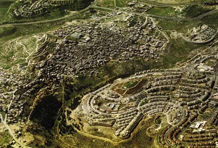
We did not want to fight nature. At no point did we want to have a retaining wall more than 2 meters high. This is a mountainous area – its morphology resembled an open palm. When I made the first sketch I placed the town center in the ‘middle,’ and the neighborhoods on the ‘fingers.’ The areas in between – the valleys – remained open and untouched, leading directly to the heart of the town.
The houses were terraced, without pilotis, and all the pedestrian routes connected to the green areas without crossing the main roads. It was a very simple scheme – a ring, with those living inside it never having to cross the internal roads. This created a very safe environment for children.
What made the buildings in Ma’ale Edummim unique at the time?
We used climate specialists and set up climate measuring stations. This was considered revolutionary. At the time the whole of the State of Israel looked like Holon and Bat‑Yam – apartment blocks of four stories on pilotis. One of the recommendations of our climate specialists was not to build on pilotis but on the ground – this was because of the winds. The Ministry of Housing was very skeptical on this point and said that it could not get a good price for ground-floor flats. We said the opposite – if you raise the ground floor about a meter off the ground, it sits above the road but it allows you to give the ground floor a garden. You give better conditions than the first floor. Today everybody does it, but then – it was a novelty. It was a battle, but as it was a new town they decided to experiment. They made the experiment and, of course, the proof is in the pudding – the flats with the little garden in front sold best.
How did the issue of view come into the question?
In Ma’ale-Edummim we have two views: The scenery of Jerusalem with its towers and the distant view towards the Dead Sea and the mountains of Edom. We had to take care to preserve these views because this is what we were selling. We were selling something that did not cost us a penny; all we had to do was be careful and not do something stupid that would hide the view that was already there.
Were you also involved in choosing the site for Emanuel?
Choosing the site for Emanuel was an entertaining process. A group of Ultra-Orthodox developers came to me with a 1:50,000 map , with six points marked on it, each measuring two or three hectares, and they told me that they want to build a town. I did not take them very seriously – but if someone comes into your office you don’t throw them out. So I took their map and I said: ‘What you have shown me is not a town.’ Then they asked: ‘What do you need for a town?’ So with a 6B pencil I drew on the map what should be the size of a town and they told me ‘you have it, start planning.’
This is how it was. I started planning and they went and checked who owns all the parcels of land. Part of the land belonged to Arabs who lived in Jordan and in London, so they simply went out and bought it from them. By the time I had finished planning they had finished buying, more or less according to the circle I had drawn.
I did not take them seriously. I wanted to discourage them so I drew them a circle, but what could I do that they came back with the circle.
How did the work on the planning of Emanuel develop?
In Emanuel the situation was one where you had young developers that had no money. They had no money to make a survey of the area, and certainly no money for traffic planners and the like. So they came to me and told me ‘design a city, but know that we have no money for anything.’ So instead of sending surveyors to the site we took large-scale maps and enlarged them up to the scale of 1:1,000. We decided, as we were not road engineers, that we would simply lay the roads on the natural morphology, that we would not change the mountains at all. It was as if you were to take a topographic line from the map and make a road on it – this is how it was built.
As the slopes in Emanuel are much steeper than those of Ma’ale Edummim, we developed buildings that can work on steeper slopes, with the building itself acting as a retaining wall. The stepped building supports the slope while the road accurately follows the contour of the topography. The result was that we achieved very cheap construction because we did not have to pay for the retaining walls.
In the beginning Emanuel was a great success, like Ma’ale Edummim. It gave an answer to all the young Ultra-Orthodox couples that could not afford the prices in Bnei-Brak, [v] which is one of the most expensive cities in Israel. The Ultra-Orthodox population has special needs and cannot live anywhere like you and me.
As the land was purchased relatively cheaply, and the government helped by subsidizing the infrastructure, the developers were able to offer flats priced at a quarter of what you would pay in Bnei-Brak or Jerusalem. It was a great success at the start. Its downfall came when a few businessmen put their hands in the cash-pot. Until this happened though the city experienced a meteoric rise. We ourselves built more than 1,500 flats.
What was the urban concept of Emanuel?
By and large we once again took the morphology we had and on it we built the town in the most fitting and cost effective way – in Emanuel we had no money for landscaping.
How was the architecture of Emanuel determined?
On the one hand, the morphology of the area dictated the stepped buildings and the retaining walls, while on the other, the architecture was determined by the specific needs of the population, characterized by religious requirements combined with limited resources and large families.
This means that you have to design rooms that will house four or five children. The basic module of a room is the bed and you have to arrange it wisely, like in a submarine, one bed on top, or next to the other.
The design is to an entirely different standard, as each flat has to have a special sink for Passover as well as a second sink for every day use, and each flat has to have a balcony that should be open to the sky for a Sukkah. [vi] This was the story of Emanuel.
We have three examples of cities you built from scratch, or almost so – Abidjan in the Ivory Coast and Ma’ale Edummim and Emanuel in Israel. Are there any similarities in the design?
In the Ivory Coast we were dealing with the design of a city that on the one hand had to serve the French and the other European communities as well as tourists, while on the other it had to relate to the traditional African villages that were in the area and needed to remain in the area.
In Abidjan, when the commercial center sits next to an existing village, it does not touch it. This allows for the necessary accessibility and provides the village with the possibility to grow and develop, while retaining the existing separation. People like to meet out of choice, not because someone forces them to. This is the principle we applied here.
In Abidjan there are two communities that need to co-habit, whereas in Emanuel there is a distinctively homogenous community.

Did the Arab villages that can be seen in the area, influence your architecture?
I look upon the morphology of the Arab villages with envy. The beauty of the Arab village lies in its accumulative and somewhat irrational nature – development progresses slowly, with each generation adding on to the existing fabric built by its predecessor.
Our approach on the other hand, determined by the government, produces an instant-city. In three years we churn out a couple of thousand flats – everything is built on one concept, one system of construction and infrastructure.
For them it is different. In the beginning there was a donkey’s track. A man builds a home, a son is born, the son gets married and they need to add something, so they add it on to the area of the street. But while there was still room enough for the donkey there is no room for the car and all that it entails.
But if you look logically at this process, by today’s standards, you can’t build a city this way. You can’t pass the necessary infrastructure or traffic and you can’t provide a minimum level of services. But in terms of beauty they are way ahead of us!
Architecture without architects – this is the Arab village, and this is its beauty; it is always better than when an architect comes in, the architect only spoils things because the architect has to work logically, and they do not.
How do you see Ma’ale Edummim and Emanuel today from the political perspective and from the perspective of their urban development?
I think that the fact that Ma’ale Edummim was created by a government decision and within the national political consensus gave it great strength that helped it through the years.
Ma’ale Edummim is also an excellent example of the great importance of the government bringing a city to a take-off threshold quickly.
This was the strength of Ma’ale Edummim and the weakness of Emanuel. Emanuel was given the first push but it didn’t reach a take-off threshold, and then someone put his hand on the cash.
As to the politics of Jews and Arabs I cannot contribute because I am very weak on politics.
To tell you that an architect influences politics? He doesn’t. The whole story of Judea and Samaria could have been different, but this is on levels that are neither in your hands nor in mine.
[i] Judea and Samaria is the preferred term used by the Israeli Right and the Settlers for the West Bank. The Israeli Left and the Palestinians, on the other hand, prefer the use of the term Occupied Territories, which also includes the Gaza Strip. (Leitersdorf uses both terms in the conversation.)
[ii] Yamit was an Israeli town built in Sinai and eventually evacuated in 1982 following the peace treaty with Egypt.
[iii] Azaria and Abu-Dis are two Arab neighborhoods in East Jerusalem on the road connecting Jerusalem to Ma’ale Edummim.
[iv] The Allon Plan was suggested by the Israeli Minister Yig’al Allon (1967). Its basic premise was that Israel should settle only in areas with sparse Palestinian population.
[v] Bnei-Brak is city near Tel-Aviv inhabited mainly by Ultra-Orthodox Jews.
[vi] The Sukkah is a temporary structure erected during the Jewish holiday of Sukkot. This structure has to be under the sky.
 APJP
APJP